

 JaamZIN

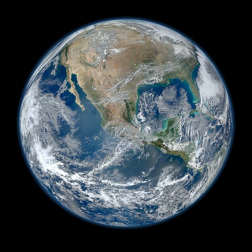
Most Amazing High Definition Image of Earth - Blue Marble 2012, a photo by NASA Goddard Photo and Video on Flickr.
January 25, 2012
A 'Blue Marble' image of the Earth taken from the VIIRS instrument aboard NASA's most recently launched Earth-observing satellite - Suomi NPP. This composite image uses a number of swaths of the Earth's surface taken on January 4, 2012. The NPP satellite was renamed 'Suomi NPP' on January 24, 2012 to honor the late Verner E. Suomi of the University of Wisconsin.
Suomi NPP is NASA's next Earth-observing research satellite. It is the first of a new generation of satellites that will observe many facets of our changing Earth.
Suomi NPP is carrying five instruments on board. The biggest and most important instrument is The Visible/Infrared Imager Radiometer Suite or VIIRS.
To read more about NASA's Suomi NPP go to: npp.gsfc.nasa.gov/index.html
Credit: NASA/NOAA/GSFC/Suomi NPP/VIIRS/Norman Kuring
NASA image use policy.
NASA Goddard Space Flight Center enables NASA’s mission through four scientific endeavors: Earth Science, Heliophysics, Solar System Exploration, and Astrophysics. Goddard plays a leading role in NASA’s accomplishments by contributing compelling scientific knowledge to advance the Agency’s mission.
Follow us on Twitter
Like us on Facebook
Find us on Instagram
HP Parts Catalog
 Posted in: blue


0 blue comments:
Post a Comment